Sunday 2 August 2009

Cultural Exploration & Digital Storytelling

Lancashire County Council and Preston City Council are working in collaboration with the Sandbox in using new cultural mapping strategies to explore cultural and social relationships in communities and for business alike.

The sandbox uses mobile phones and GPS technology to allow participation to document, record and write experiences in real-time and upload those files via video, SMS, sound and image directly from the mobile phone to a website to be shared with the all participants. Web-based projects provide a space for communities to utilised new social media tools to connect to others and be active author in promoting their values and local needs.
Sandbox facilitators employ new creative media tools, designed specifically to enable participants to gather and store relevant information, to bring people, their stories and digital technologies together in a creative and user-friendly way.

Wednesday 29 July 2009

Stickers with embedded RFID barcodes

New Cultural Journeys could develop its own brand of stickers for bicycles and for urban furniture to track how far the NCJ project has reached into communities or along the coast. By embedding RFID tags into the stickers - a scanning device such as a mobile phone could pick up information from each tag site.

Stickers or bicycle transfers could be designed by participants themselves to decorate their bikes or other urban wear! NCJ stickers are a fun way to brand a project and to monitor the way the project is valued by the people taken part!!

NCJ Stickers can also be used to promote the cycling sport in numerous ways! The design can brand the project as well as the count down to the Olympics 2012 and beyond!

Tuesday 28 July 2009

2012

At the 2012 Olympic Open Weekend Conference on the 24th July 2009 it was revealed that the theme of the Olympic torch relay is:

"high streets and back streets"


twitter :: journeys in real-time

Twitter is fast becoming the social networking site and real-time commentary of what people are doing. Twitter is used not only to connect to others for business purposes, for similar interests or to follow a certain social topics - but also to comment on what is happening in their neighbourhoods, cities and the traffic -- right at this moment!

The best example for real-time "tweeting" or "tweets" is from New York city providing its citizens with a twitter page to chart the transport system. 511NY.

People can sign up for traffic and transit twitter updates:


People can also follow tube lines and follow progress for specific regions.


I blog this because the use of - social networking technologies - can be an effective and inclusive way to engage with people of all ages to participate in a project. It gives people a space to voice their own opinions and to make comments as well as to link the project into other interests they may have.

Monday 27 July 2009

New Cultural Journeys

Imagine!!! Capturing the rain or changes in the weather and turning this into a sound space of information, a local narrative or participatory game space! The idea would be to use transmitters to network the public into a common art experience along the coast of Lancashire.


Hertzian Rain by Mark Shepard - is a live sound project which filters multiple sound and is streamed from a set of wireless transmitters placed in an urban space. The transmitters broadcast the live audio stream locally on the same radio frequency to participants who are wearing wireless headphones tuned to this frequency.

This event is designed to raise awareness of issues surrounding the wireless topography of urban environments through audio experiences based on sound and movement.

Participants carry umbrellas made of electromagnetic field (EMF) shielding fabric that enable them to actively shape the surrounding environment of radio waves. By orienting the umbrella in different ways, one is able to filter the interfering radio signals and select a single audio stream to listen to. The movements of the crowd are sensed by accelerometers attached to the umbrellas and this data is broadcast locally to the sound makers via an ad-hoc wireless network, who in turn use these data streams to modify the sound streams.

Sound sources might include real-time ambient sounds produced by a sound artist, a spoken word performance or live music from a local or remote location mixed in real-time by mobile DJ, for example.

This is one of many exciting projects by Mark Shepard.

Sound Garden + Networked Public Spaces

The Tactical Sound Garden [TSG] toolkit is an open source software platform for cultivating public "sound gardens" in the city. It can be used to create social public spaces for people to participate in an digital environment to build a technologically mediated garden.

Working with mobile audio devices like the iPod, the toolkit enables anyone with access to wireless (WiFi) "hot zones" to install a "sound garden" for public use. Using a WiFi enabled mobile device (PDA, laptop, mobile phone), participants "plant" sounds within a positional audio environment.

These plantings are mapped onto the coordinates of a physical location by a 3D audio engine common to gaming environments - overlaying a publicly created soundscape onto a specific urban space. Wearing headphones connected to a WiFi enabled device, participants drift though virtual sound gardens as they move throughout the city.

Invader :: Street art play & cultural mapping

Invader is an artist who uses the city as his canvas to place mosaic characters of the computer game SPACE INVADERS throughout the city. This has been done in cities across the world, with maps and images of these mosaics available online. There are many websites where the public have documented these INVADERS themselves and how many times there been seen to build on the artist's map.


Creating a cycling route along the Fylde coast, around Morecambe, throughout the city of Lancaster and Preston; new street art, sound scapes or outdoors games could become part of a cultural mapping environment where people cycle from A-B in search of new art installations.

To see some of the images captured by the public of Invaders in various cities go to:
BIG ART MOB


Research -- Bike Sharing

Research provided by Bike Sharing Solutions

Bike Sharing Solutions :: Cyclocity

How can Lancashire raise the bar to provide 4th generation bike sharing facilities in the future?


1) The first generation of bike sharing began in 1967 in Amsterdam!! Normal bikes without locks simply painted white where provided for public use - as you can imagine, things did not go as planned as some people abused the system.

2) In the late 1990's, the second generation of bike sharing was launched in Copenhagen, Denmark. These bikes were specially designed to be picked up and returned at specific locations (racks) with a coin deposit (like super market trolley).

3) The third generation of sharing bikes uses electronic locking racks, or bike locks, chip cards, mobile phones and internet. These new systems 'know' who uses the bikes and people can be tracked. In 2007 Paris started Velib, ran by advertisement company JCDecaux. The success of Velib generated enormous interest in bike sharing around the world...

There are a variety of bike sharing options and a lot of case studies to learn from all the existing systems to choose the best model to work in Lancashire! Here are a few different systems:

  • Clear Channel: Barcelona, Washington DC, ....They provide a turn-key program in 13 European cities and recently started its first American program, the one in Washington.
  • JC Decaux: Paris, Lyon, ...
  • Call a Bike: Berlin, ...
  • Next Bike: Germany
  • OV-fiets (Public Transport Bike): Netherlands

Call a Bike

Call a Bike is a bike hire system run by Deutsche Bahn in several German cities, which uses a system of authentication codes to automatically lock and unlock bikes.


To hire
Customer calls the telephone number given on the bike which includes the bike's ID and gets by voice the 4 digit opening code, which he then types onto the bike's touch screen to unlock it

To return
Lock the bike to a fixed object, and select "return bike" from the bike's touchscreen. A code will be generated which then has to be telephoned to the control centre, as proof that the bike was locked. As well one has to give the exact street names of the cross roads, which has to be within the permitted town area.

The Technology involved
Comprised of an electronic wheel lock and a cable lock, all controlled by embedded microcontroller with touchscreen LCD display. A set lock/unlock codes are unique to each bike and stored in memory.

re:blogged from Wikipedia

MAP - Memories about Preston

MAP, is an online mapping project that offers members of the Preston community the opportunity to share their own opinions, stories and memories of the city centre. This interactive mapping project was developed in association with the Harris Museum & Art Gallery’s Access and Inclusion department.


This project was launched as part of the In Certain Places project: City Conversations: a collection of artworks which explore the city as a site for dialogue and exchange. The core idea was developed to provide alternative ways of communicating and sharing memories, and to encourage conversations about Preston city centre. This project was developed by artist Chris Davis of Alison who also developed The Family project.

New Media Glossary & Terms

Here are a few explanations of the new media terms used in this blog:

Augmented Reality

Overlaying virtual images on top of real images through the use of computer technology. For example a video might track you walking across a screen environment and suddenly a virtual creature appears on screen next to you.

Blogs
A blog is essentially a website that contains information posted by a dedicated user or a group of bloggers. A blog can contain news items, short essays, annotated links, documents, graphics, and multimedia. A blog is normally accessible to any Internet user.

Bluetooth
This is a wireless system, which allows different devices to communicate with each other. Portable computers can link to desktop computers or network between mobile phones via Bluetooth. Bluetooth transmits a signal over short distances (up to around 10 meters) between telephones, computers and other devices without the use of wires.

Global Positioning System (GPS)
Digital navigation technology. The ability to find out where you are in the world via a satellites to give correct location data.

Hybrid Space
New forms of digital architecture combining virtual/digital space with real/physical place. Previously separate media such as film, graphics, still photography, animation, 3D computer animation, and typography, are now overlaid and merged in numerous ways to create hybrid space where both realities can be explored simultaneously.

Interface
Interfacing is the way in which people use technologies. A mouse or keyboard is the way we usually interface with computers. For games machines and consoles we use a joysticks as the interface to the game world. There are also software interfaces that enable one program to link with another.

Locative Media
Digital media technologies such as Global Positioning System (GPS), Geographic Information System (GIS) used in real outdoor spaces to enable social connections, networks and interactions. Google Maps for example uses location-aware media.

New Media
Term which embraces all of the 'new' forms of electronic media -- newer than TV and radio, that is -- such as multimedia CD-ROMs, the internet, and video games. New media describes a variety of artistic practices that use analogue or digital technology within an electronic and/or internet domain.

Pervasive / Ubiquitous Computing
The term “Pervasive Computing” was introduced by IBM in 1998 and describes the integration of computers in our surroundings – computers embedded into architecture for example – computer being everywhere and very applicable to the mobile device being omnipresent, pervasive.

Pervasive computing is the trend towards increasingly ubiquitous (another name for the movement is ubiquitous computing), connected computing devices in the environment, a trend being brought about by a convergence of advanced electronic - and particularly, wireless - technologies and the Internet.

User Generated Content
Public can interact and contribute to news websites via text messages and images or create their own digital content such as for online games that can be accessed and edited by other users

WI-FI
Wireless networking is a way of transmitting information without cables that is reasonably fast and is often used for laptop computers within a business or a university or school campus instead of a Local Area Network (LAN) that uses cable connections. Wifi systems use high frequency radio signals to transmit and receive data over distances of several hundred feet.

Friday 24 July 2009

SMARTcode, SemaCode and Tagging

Semacode is a type of barcode. Instead of parallel lines, Semacode looks more like a jumbled pattern of black and while squares - like a crossword puzzle. The coded information can connect users to the Internet to get more information including images or directions.

Until now, Semacodes have been used with mobile phones with built-in cameras! The user can capture a semacode while on a journey through the city, access a website with information about where they are and download the info back to their phones.

Data Matrix Symbol

Graffiti Research Lab :: LED Throwies

LED Throwies are developed by the Graffiti Research Lab part of the Eyebeam R&D OpenLab.

LED Throwies can add color to any ferromagnetic surface in your neighborhood. LED are a fun and inexpensive way to get playful with your environment. Objects or surfaces can be painted with magnetic paint to which Throwies can attach.

A Throwie consists of a lithium battery, a 10mm diffused LED and a rare-earth magnet taped together. Throw it up high and in quantity to impress your friends and city officials.

RFID -

Radio Frequency Identification is gaining a wider acceptance as a robust interactive technology that can be used for many applications. The simplist way to descipt RFID is to think of it as an electronic barcode. RFID tags stores data relating to an item, an object or even a place and is read by a bar code scanner using optical or infrared wavelengths.

Blitz-light :: RFID tags and City Games

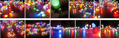
More Lights to Dark City Spaces!
Welcome to Blitz Play Hero!


Blitz-Light use interactive tags, circuit-bent electronics (in the shape of small trees) and Nintendo DS Light game consoles to create a live street concert of sound and light. The wireless network becomes activated by players (or cyclists) carrying small sound-amplifiers on their belts or which can be fitting to a bicycle.

The trees start of light up with bright coloured LED lights when in contact with the RFID tag.


Based on the sequence of the RFID tag (which works like a bar code) various sounds are generated on the DS light console. The numbers and sounds are then transferred to an online map which charts the players throughout the city. Great way to see your journey through the city!


There are 3 main game levels:

In LEVEL 1 players use the DS to “sniff” out open and closed WIFI hotspots. These are marked as playclouds (areas in the city where RFID tags can be placed). Players or cyclists chalk the symbol of a DS d-pad knob to indicate that a playcloud has been created. The location of the playclouds are stored on the DS as text file and is up-loaded to a Google map to store the data. This game data is overlayed on a map of the city with black and white polygons to represent players location.

The playclouds are assigned a base sound, used later in the concert, and at this point a player can view the map and begin to create a score of music, or simply use it to locate their nearest open WIFI spot.

LEVEL 2 invites players to find the playclouds and place RFID tags at their location. The system automatically assigns them a sound. This again is stored on the DS and transferred to the online map - updated with each tag.

LEVEL 3 is the live concert.
Players return to playclouds, scanning their own and other player’s tags, to play the sound on the DS. Each player becomes an instrument in the orchestra of RFID readers.

Throughout the levels players are awarded points for finding clouds, placing tags, and generating music, and thus the Blitz Play Hero is declared.
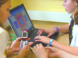
Active Audiences // Engaged Public

Creative potential of mobile devices are a significant emerging media platform that can be used for innovative projects across cultural actives. Tools such as navigational technologies such as GPS, messaging services via SMS and digital image exchange via MMS - provide an interactive network between artists, audiences and the world around them. Mobile and wireless communication devices - in the hand of the public - allow their involvement in the creative process and to actively shape their own art experience.

Mobile communication devices can be used for projects that involve:
- Episodic narratives; text messaging
- Cross-platform production; image, sound and video up-loads
- Digital audio spaces; using GPS or RFID tags
- Mapping virtual and physical spaces; location aware technologies, Smartcodes

SKYRIDE A New Journey Through Manchester

On Sunday 2 August 2009 get your bike and enjoy a cycle through a traffic free Manchester! Sky in partnership with British Cycling and Manchester City Council created a 11.5K city centre route through the city.

Explore places such as:

  • Chinatown
  • Albert Square
  • Sportcity
  • the Velodrome

Wednesday 22 July 2009

Mapping Fylde Coast, Morecambe and Lancashire

To help in the design of a new cycling path or public path - one which is interactive and responsive to the way people use and navigate their journey - a new trail would need a form of WAYFINDING nodes to help guide riders along as well as to pin-point where along the journey the path becomes interactive....

New mapping applications (digital) and identification markers (physical) may need to be considered to help people use and navigate the environment with GPS devices such as the mobile phone.

The Mobile City


The Mobile City is about Mobile Media // Urban Culture // Locality
Mobile media has become an interface between virtual spaces and the city! Merging the digital world with the physical world, people can upload and share real world experiences back to the digital world with other people.

The Mobile City project describes the use of location aware technologies and mobile devices to understand how those technologies can transform our experiences of urban culture.
  • working with interfaces referencing space/map/places; for instance Google Earth-mash ups or TomTom devices.

  • creating interactive, responsive geographic places for teh design of maps, to build on local meaning and chart new territories.

  • trace objects and people on the move using locative media and to coordinate realspace social networking.

  • using of locative media as a ‘space making devices’, altering the experience of a certain space through mobile phones SMS for example.

Get Out & Explore!!


"Interact with the world in a whole new way".
Experience sounds and images linked to the landscape.

Discover a rush of info as you turn a corner
!
There could be a challenge awaiting you.
Imagine the games you can build...
The stories you can tell....

Welcome to Mediascape!
Immersive media — games, guides, stories — woven into the landscape.

For information about how to employ Mediascape check out the press kit giving you video links and useful technical descriptions.


Biking Dynasty ::: Looking to 2012!!

The YouTube online-TV soap that features video taken from the renown sporting dynasty: The Athertons. The video series gives a behind the scenes view of three of the most successful cycling siblings in Downhill Mountain Biking, what makes them tick and what motivates them and the various races....

NY Bicycle Film Festival

The New York Bicycle Film Festival took place in June, 2009. Its remit is celebrating the bicycle!! The idea is to engage with the lifestyle of cycling through art, film, music and performance and to advocate the bike as formidable transport device!

The programme is filled with action-based film footage shot by a variety of cycle enthusiast:

1) DRAG RACE NYC
City bike race between cars (caution this is risky business)


2) LONDON CALLING

Mad Skills - London's finest doing the High Tech Weave (HTW) in this high speed alleycat:


Cool Bike Design for 2012

Monday 20 July 2009

Ludus Dance : Text Messaging and Choreography

During the f.city Festival in Lancaster 2006, the public were invited to take part in Ludus Dance activities receiving dance instruction and directions via text messaging and video podcasts! Via online video, people were able to learn simple dance steps and receive tuition and instructions before dancing live in the city.

Ludus Dance based in Lancaster and is Britain's leading dance in education company. They produce issue-based dance theatre performances that tour to schools and theatres across the UK and internationally.

online video people could view before the big performance

Saturday 11 July 2009

Rider Spoke: Urban explorations

"Rider Spoke is a work for cyclists combining theatre with game play and state of the art technology."

Rider Spoke is an artwork by Blast Theory investigating how games and emergent communication technologies can bring together new social encounters both on and offline.

The work invites people to cycle through the city in search of interesting, secluded places and to record a short message there. Equipped with a handheld mobile phone people leave messages but also cycle in search of other peoples hidden messages.

Songbike

"Come out for a ride + make a bicycle soundscape"

Songbike is a sound-based project by artist; Kelly Andres. Installed on a bike, is a mobile sound lab, which records and automatically uploads audio to a website. Songbike connects people with shared interest in community and aurality; allowing them to self author and self-produced content and social interaction.


Mobile Sound :: Sonic City

Sonic City is a project that presents the city as a musical instrument. The project imagines the city in terms of a sound and music space, giving the people in those urban spaces the ability to create sound and experience musical compositions. The city becomes an interactive musical interface.


Sonic City enabled people to create music by walking through a city. By using wearable mobile computer technology - the perception of place, time and the activity applied to exploration the urban sapces turns into personal audio creation.
"We explore the use of public space and everyday behaviours for creative purposes, in particular the city as an interface and mobility as an interaction model for electronic music making."
The city becomes an interactive and physical interface. The architecture and urban surrounding provide a built infrastructure to use creatively. The everyday activity of walking or cycling through the urban space can be translated into movement and choreography and captured by the city interface. Through the use of mobile and wireless tools this movement can be translated into narrative and creative feedback.

Sonic City was created by Ramia Mazé, Play Studio, Lars Erik Holmquist, Future Applications Lab and Lalya Gaye, Future Applications Lab, Viktoria Institute.

Friday 10 July 2009

Mobile Sound: Walking and Listen

AURA, is project by artist Steve Symons, which allows people leave a digital audio trail as they move and walk through their physical surrounding.


People take a backpack and headphones on a walk and in a defined radius the walker experiences sounds at specific areas anchored by GPS points.

Sound to drive a narrative journey

Artist are using mobile and wireless technologies to overlay digital information onto real spaces.
Audio sounds can be embedded at a certain location and information triggered to which it refers.

Imagine walking or cycling along the water front and as you pass certain digital makers, you will be able to hear sounds, music or a narrative...


Walking & Drawing: Mapping your journey

Jeremy Wood is an artist who uses GPS navigational technologies to map out his journeys as a drawing. The line drawings become a personal document of the playful; walks he creates. Part of this physical map making, Jeremy designed the biggest IF and other fun words.
Snapshot of walks created by Jeremy:

Tuesday 30 June 2009

Landlines: Mobile GPS drawing tool

Landlines software was developed by artists Jen Hamilton & Jen Southern in conjunction with ONTECA Ltd to gather live GPS data. The unique tools becomes an interactive vehicles for people to learn and talk about the nature of a place, and its meaning to local people. These projects can be seen at portable TV.

>> your journey outlined on google maps <<

Landlines is a multi-user drawing tool for mobile phone and bluetooth GPS, that allows users to draw by moving in real space. As you walk through the city with Landlines your latitude and longitude is periodically sent via mobile phone to a database. A website then displays your live tracks.


Mobile exploration of location & place - NW

The artwork of Jen Hamilton, Jen Southern & St Amand investigate social and tactile approaches to technology and work with audiences to explore location and sense of place. Their projects explore how new technologies influence the way we inhabit an environment and collaborate with industry on the development of new tools for creating collaborative maps.

running stitch

Distance Made Good: Flow Lines (2004), Hamilton and Southern worked with local people to make a new map of Lancaster and Morecambe, UK, by using the Landlines system based on the lives of the people living and working there, and of the places.

The walkers (a group of local residence) were invited to make journeys that in some way represent who they are in conjunction with being a landmark for the city they live in (e.g. A participant in Morecambe took us for a walk along the seafront, as for him the seafront represented Morecambe, and it was a route he regularly took when walking his dog).

Thirty four walks were recorded using a GPS device, and were represented together in the gallery on two map like screens folded into the space.

In their project: Running Stitch (2006) the artists gave exhibition visitors a GPS-enabled mobile phone to track their journeys through the city centre. These walks created GPS line drawings of the walker's movements projected live in the gallery to disclose hidden aspects of the city. Each line drawing was sewn in real time into a large 5m x5m hanging fabric to show an evolving tapestry that revealed a sense of place and interconnection between the walkers and the city. (re:blogged from their respective websites)


Question >>

What are the transformative qualities of digital technology - specifically those of mobile and wireless media - and how do these new channels of communication inform and inspire young people to think and act creatively?


Mapping & Community Engagement - Liverpool


Liverpool-based artist Alan Dunn worked in collaboration with Re-Dock throughout 2009 to develop a series of creative consultations, inviting communities from North Liverpool to put forward imaginative ideas for the future of Leeds-Liverpool canal.

Cultural mapping projects and working in situ with communities is becoming a strong methodology for creating interactive and participatory projects involving mobile and wireless technologies. Through the use of location aware media mobile technolgies (these include GPS location devices) audiences are given tools to author or input their own information about where they are or what they find important in their surroundings at any given moment.

Mobile technolgies are tools that can inspire >> real world << interventions as well as allow people to network between each other sending and sharing creative content including photos and videos.

Monday 29 June 2009

Short Shap Shorts - NW of England


Short Shap Shorts was a ground breaking mobile phone film making competition commissioned by North West Vision+Media in 2007. The competition was open to
18-24 year olds to create stand alone films by just using the video function on their mobile phones. The idea for Short Shap Shorts was for the NW screen agency to identify, meet and support hot new young talent in the region and to engage them in the latest of film making techniques - using mobile media devices!

To see the selction of winning flims please visit the short sharp shots myspace site.

This project followed a growing trend for exploring new broadcasting models to reach new audiences especially those of younger people. Example of film festivals exclusively for mobile film content are now creating a new strand of digital entertainment and creative talent forums all over the world.


MOBI FEST
made for mobile movies

Mini Series

Experience the visual seduction stories told for the mobile generation.


The Burgess Project - Manchester


The Burgess Project was an exciting project produced by the-phone-book Limited,
exploring new technologies, new modes of writing and engagement with new audiences. It was launched during the innovative freeplay strand of the inaugural Manchester Literature Festival, in October 2006, where Literature, Technology & Media came together.

Through the use of Bluetooth and mobile phone media, the public were able to par-take in the Burgess narrative whilst taken on a grant tour, a promenade performance through Manchester that linked several venues across various city centre venues. A full story line and project description can be found online with a link to a video screening.